






By Annemarie Mannion
The state of Indiana is grappling with the aftermath of an unprecedented meteorological event that has left its transportation infrastructure in shambles. Between August 11 and August 17, a relentless combination of a derecho and a 1,000-year rainfall event devastated the Hoosier State, dropping as much as 14 inches of rain in a mere 10-hour window. The resulting destruction—ranging from catastrophic bridge collapses to the total washout of key federal-aid roadways—has prompted a massive federal intervention.
The Federal Highway Administration (FHWA) has announced an initial allocation of $26 million in "quick release" emergency relief funds to expedite the restoration of essential transportation links. As state and local engineers begin the arduous process of rebuilding, the scope of the damage serves as a stark reminder of the increasing vulnerability of aging infrastructure to extreme climate volatility.
The Anatomy of the Disaster: A Chronological Overview
The destruction began in mid-August, as a severe storm system swept across Indiana, characterized by hurricane-force straight-line winds, multiple tornadoes, and localized flooding that defied historical meteorological records.
- August 11–12: The initial front strikes. Intense precipitation begins to overwhelm drainage systems across central and northern Indiana. Rapid saturation leads to immediate flash flooding in low-lying areas.
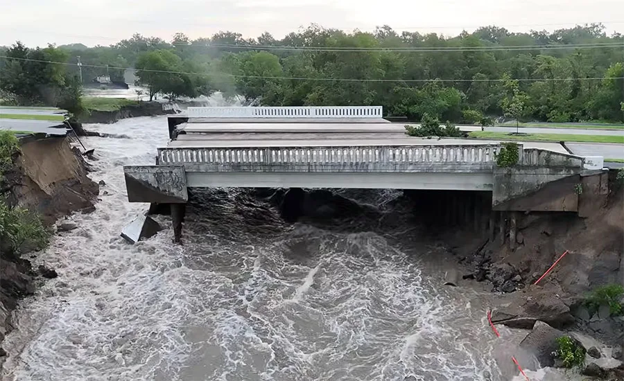
- August 13–14: The peak of the disaster. A “1,000-year” rainfall event delivers 14 inches of water in under half a day. The Hazel Dell Parkway Bridge in Carmel, a vital artery for the suburb’s 100,000 residents, succumbs to the hydraulic pressure and scouring, collapsing into the swollen Blue Woods Creek.
- August 15–17: The storm’s reach expands. Infrastructure damage is reported on a massive scale, including the degradation of Interstate 70, State Route 38, and numerous bridges throughout Wayne County. Power grids fail, and water inundates residential and commercial sectors.
- Late August: Governor’s offices and the Indiana Department of Transportation (INDOT) conduct preliminary damage assessments. State officials coordinate with the FHWA to declare a disaster area, paving the way for the $26 million emergency relief injection.
Infrastructure Impact: The Hazel Dell Parkway Collapse
The most visible casualty of the storm is the Hazel Dell Parkway Bridge in Carmel. A critical north-south connector for commuters traveling to Indianapolis, the bridge served an average daily traffic (ADT) volume of more than 10,000 vehicles. Its sudden loss has severed a primary logistical lifeline, forcing thousands of residents into lengthy detours and highlighting the fragility of suburban transit corridors.
Local officials in Carmel have estimated the replacement cost of the structure at $10 million. However, the complexity of the rebuild extends beyond mere construction. Hamilton County engineers are currently tasked with a multifaceted engineering challenge: they must not only replace the bridge but also evaluate the feasibility of realigning Blue Woods Creek.
During the storm, the hydraulic dynamics were so extreme that the White River, surging well beyond its banks, effectively reversed the flow of the creek. This caused water to back up into a nearby quarry owned by Martin Marietta. The flooding of the quarry halted industrial operations and created a secondary environmental and economic crisis. Carmel officials are currently developing a comprehensive de-watering plan to stabilize the ground conditions surrounding the site, a prerequisite for both quarry operations and bridge foundation work.
Supporting Data and Engineering Challenges
The intensity of the August event has forced a re-evaluation of current engineering standards. When hydrologists designate a "1,000-year event," they refer to a flood that has a 0.1% chance of occurring in any given year. The fact that such an event occurred in Indiana, causing widespread destruction of federal-aid highways, suggests that the parameters for infrastructure resilience may need to be fundamentally rewritten.
INDOT reports that the damage was not limited to bridges; it was a systemic failure of drainage and roadbeds. The saturated soil, combined with high-velocity runoff, caused "scouring"—the removal of sediment from around bridge piers and abutments—which is the primary cause of bridge failure during flood events.
The $26 million in federal funds is categorized as an initial "quick release" installment. This funding is specifically designed to provide immediate cash flow for debris removal, road stabilization, and the repair of temporary crossings. However, state officials acknowledge that the total cost of the recovery will likely far exceed this initial sum. Future allocations from the FHWA’s nationwide Emergency Relief program will be required to bring the damaged infrastructure back to, or above, its pre-disaster functional state.

Official Responses and Federal Oversight
The response from federal authorities has been swift, emphasizing the necessity of restoring economic mobility. "The emergency relief funding we are providing will help the state quickly fix broken transportation links so people can get back to work, run their businesses, and get back to their daily routines," said FHWA Administrator Sean McMaster in a press release following the funding announcement.
The FHWA’s Emergency Relief program serves as a critical safety net for states, territories, and tribal nations. By providing funding for the repair of highways and bridges damaged by natural disasters, the federal government ensures that local tax bases are not permanently crippled by the sudden, massive costs associated with extreme weather events.
At the state level, INDOT is working around the clock to prioritize projects. The focus is currently on "critical path" infrastructure—routes that facilitate emergency services, school bus transit, and major commercial supply chains. In Wayne County, for example, repair efforts are focused on stabilizing multiple bridge crossings that serve as the backbone of the county’s agricultural transport network.
Broader Implications: A Climate-Resilient Future?
The Indiana disaster is part of a larger national conversation regarding the durability of American infrastructure. As the frequency and severity of "extreme weather" increase, the engineering community is moving away from traditional design models that rely solely on historical climate data.
H3: The New Standard for Resilience
The destruction of the Hazel Dell Parkway Bridge and the surrounding washouts provide a case study in why "resilient design" is moving to the forefront of civil engineering. Engineers are now being urged to:
- Re-evaluate Hydraulic Modeling: Incorporating climate change projections into drainage and bridge-pier design to account for more intense, shorter-duration rainfall.
- Incorporate Nature-Based Solutions: Using wetlands and expanded floodplains to mitigate the impact of surge events, rather than relying solely on concrete walls and culverts.
- Prioritize Redundancy: Creating secondary routes that can handle high traffic volumes in the event that a primary bridge or highway segment is compromised.
H3: The Economic Burden
Beyond the $26 million in federal aid, the economic impact on the private sector—such as the Martin Marietta quarry—cannot be ignored. When infrastructure fails, businesses face supply chain disruptions, increased logistics costs, and the direct expense of site remediation. The total cost to the Indiana economy of the August storm is expected to be calculated in the hundreds of millions, when factoring in agricultural loss, private property damage, and the temporary loss of productivity.
Looking Ahead
As autumn progresses, the residents of Carmel and the wider Indiana community face a challenging reconstruction period. The focus remains on the rapid, yet safe, restoration of the Hazel Dell Parkway Bridge and the stabilization of the surrounding terrain.
For the Indiana Department of Transportation, the task is twofold: addressing the immediate structural scars left by the August derecho and preparing for a future where "1,000-year" storms may become a more frequent reality. The $26 million federal investment is a vital first step, but it is merely the beginning of a long-term initiative to fortify the state against the unpredictable forces of an evolving climate.
As debris is cleared and structural assessments are finalized, the engineering community will be watching Indiana closely. The lessons learned here—from the mechanics of the creek-flow reversal to the effectiveness of the rapid-response repair strategies—will likely influence how states across the Midwest approach infrastructure resilience in the coming decade.
Annemarie Mannion is the editor of ENR Midwest, covering infrastructure, design, and construction across 11 states. She has been reporting on the intersection of public policy and engineering since 2022.