




In the high-stakes world of heavy civil engineering and utility infrastructure, the most dangerous obstacles are often the ones you cannot see. For decades, contractors have relied on a combination of archaic 2D paper drawings, guesswork, and expensive, time-consuming field verification to navigate the complex web of underground pipes, electrical lines, and fiber-optic conduits that power modern society.
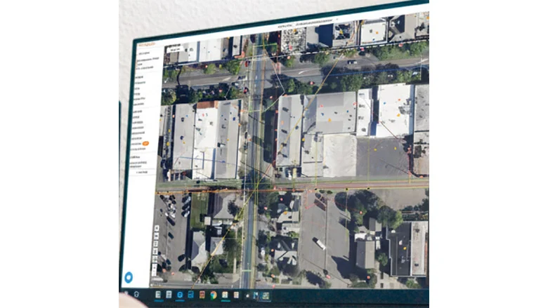
Josh Mackanic, a veteran engineer who managed over $500 million in projects for Pacific Gas & Electric (PG&E), spent his career frustrated by this disconnect. Despite the industry’s push toward Building Information Modeling (BIM) and advanced Geographic Information Systems (GIS), the "underground reality" remained dangerously opaque. In 2020, Mackanic co-founded CivilGrid—a platform he describes as "Google Maps for underground conditions"—to bridge this gap. With a recent influx of venture capital, the company is now scaling its efforts to standardize how the industry views, manages, and interacts with the built environment below our feet.
The Genesis of a Digital Infrastructure Revolution
The inception of CivilGrid was born from a culture of caution. Mackanic’s tenure at PG&E included the aftermath of the 2010 San Bruno pipeline explosion, a catastrophic failure that resulted in eight deaths and the destruction of 38 homes. That event left an indelible mark on his professional philosophy.
"It was a mindset-setting moment," Mackanic recalls. "Having that in our DNA as a company helps us understand the stakes. We need to be diligent and meticulous, not just for the sake of efficiency, but because the cost of failure is measured in human lives."
Partnering with co-founder Brandon Cohen, a former water utility manager, Mackanic set out to create a centralized repository for subsurface data. The platform aggregates utility assets, property ownership records, and environmental regulations, creating a living digital twin of the underground landscape. To date, the platform has processed data from over 10,000 projects, sourcing information from more than 3,000 utilities, government agencies, and private owners across California, Florida, and Texas.
Chronology of a Growing Geospatial Network
- 2010–2020: Josh Mackanic manages high-profile projects at PG&E, witnessing firsthand the inefficiencies and safety risks caused by reliance on legacy 2D utility records.
- 2020: CivilGrid is officially founded with the mission to digitize underground utility data, aiming to reduce locator error and improve project safety.
- 2021–2023: The platform begins onboarding data from major utilities like PG&E and Atmos, proving its utility in real-world applications by identifying "ghost" infrastructure—such as unmarked 24-inch water mains—that traditional maps missed.
- 2024: CivilGrid scales its operations, expanding its footprint across three major states and integrating diverse datasets, including environmental and property records.
- 2026: A significant funding round led by Spark Capital signals a maturation phase for the company, bringing in strategic investors like Energy Impact Partners, a fund backed by major utility companies.
Supporting Data: The Cost of "Not Knowing"
The necessity for a platform like CivilGrid is backed by sobering industry statistics. According to the U.S. Occupational Safety and Health Administration (OSHA), approximately 30% of all industry incidents are directly attributable to "locator error."
These errors occur when field workers rely on inaccurate maps or are unable to interpret complex ground-penetrating radar (GPR) or LiDAR data. Mackanic argues that the industry has fundamentally misdiagnosed the problem: "It’s not that the locators are bad at their jobs. We are putting too much weight on their shoulders. We are asking individuals to make split-second decisions based on incomplete, outdated, or fragmented information."
CivilGrid addresses this by democratizing access to data. By aggregating existing but siloed information from municipal records and utility archives, the platform provides a "single source of truth." This reduces the pressure on field crews to "guess" where a line might be, effectively moving the safety verification process from the job site to the planning phase.
The Sharing Economy for Civil Infrastructure
CivilGrid’s business model is explicitly inspired by the sharing economy. Just as platforms like Uber or Airbnb aggregate fragmented data to provide a seamless user experience, CivilGrid pools the "data exhaust" of thousands of utility projects.

"There is a tremendous amount of data we are sitting on that would be incredibly valuable to inform everyone’s projects," Mackanic explains. "It’s about recognizing that this isn’t just about one utility’s lines. Because of the expansive geospatial nature of our footprint, we are generating a collective knowledge about our built environment."
This collaborative approach has attracted significant attention from investors. The company’s latest funding round was led by Spark Capital, with participation from Afore, A*, Ford Street Ventures, and SNR. Perhaps most notably, Energy Impact Partners—an investment fund composed of some of the largest utility companies in the U.S.—has joined the fold. This indicates that the utility sector itself recognizes the necessity of digital transformation and is willing to back the tools that make it possible.
Official Responses and Strategic Implications
For major utility providers like PG&E and Atmos, the early adoption of CivilGrid was not just an experiment; it was a risk-mitigation strategy. In one specific case study, the platform successfully identified a 24-inch water main that was completely absent from traditional site documents. Had the project proceeded without that data, the potential for a localized service outage, environmental damage, or physical injury would have been high.
The broader implications for the engineering and construction (E&C) sector are profound:
- Risk Reduction: By integrating environmental and regulatory records with utility data, contractors can anticipate permitting delays and physical hazards before breaking ground.
- Efficiency Gains: Reduced reliance on manual verification and "trial-and-error" digging lowers project overhead and accelerates project timelines.
- Standardization: As more agencies and utilities adopt digital mapping, the construction industry moves closer to a standardized digital twin of the subterranean world, which will eventually be as accessible as modern street-level mapping.
- Regulatory Compliance: As OSHA and other oversight bodies tighten safety requirements, having a robust digital record of "due diligence" provides a clear audit trail for project managers and owners.
Looking Ahead: The Future of Subsurface Intelligence
As CivilGrid continues to expand, the focus remains on the "ground truth." Mackanic emphasizes that no matter how advanced the AI or how sophisticated the interface, the priority must always be data integrity. The goal is to provide a platform that enables responsible, efficient growth while honoring the lessons learned from the past.
The integration of AI—similar to tools like the newly launched "Ask ENR" for research—will likely play a future role in how these datasets are queried. Imagine a site superintendent asking a digital assistant, "What are the regulatory constraints and known utility hazards within a 50-foot radius of this coordinate?" and receiving an instantaneous, accurate answer.
CivilGrid is currently laying the foundation for that future. By turning the "invisible" into an actionable asset, the company is not just changing how we build; it is changing how we perceive the foundation of our cities. In a world where infrastructure is aging and the demands for connectivity and energy are rising, the ability to safely and accurately navigate the underground is no longer a luxury—it is a critical requirement for the modern built environment.
As Mackanic concludes, the mission is simple: to ensure that the mistakes of the past remain in the past, and that every project, regardless of size, begins with the clarity and intelligence required to build safely.